About this document
This document was designed as a supplementary material for the “Free and Open Source Geospatial Workshop for Conservationists” supported by the Conservation Leadership Programme Learning Exchange Program.
About the CLP Learning Exchange Program
The aim of this project is to build the capacity of CLP Alumni in using Free and Open-Source Software for Geospatial (FOSS4G) technologies and other related technologies and maximize the application in biodiversity monitoring, management and conservation.
Specific objectives and expected outputs are:
- Development of a series of FOSS4G learning modules that will address the specific geospatial needs of conservationists.
- Conduct of training workshop to CLP Alumni and other interested groups.
- Post event skill sharing through the CLP Ning Social Media platform.
About ESSC
The Environmental Science for Social Change (ESSC) is a Jesuit research institute with a 20-year history of engagement in local, national and regional research and dialogue that contribute to an understanding and sustainability of community-based environmental management through the development of a “science for social change”.
ESSC’s approach to environmental mapping makes significant contribution to building people’s capacities to collectively manage and plan towards an improvement of their way of life through a more responsive management of the environment.
More information about ESSC: http://www.essc.org.ph
About FFI
The Fauna & Flora International is the world’s longest-established international conservation body founded in 1903. FFI is supporting conservation initiatives and organizations through partnerships, technical support and direct funding.
In the Philippines, FFI is working closely with local conservation organizations to develop sustainable livelihoods for communities and contribute in exploring strategies on how to improve forest governance in the country particularly in southern Sierra Madre and Palawan.
More information about FFI-Philippines: http://www.fauna-flora.org/explore/philippines/
How to Use
This document is the online supplementary material for the Free and Open Source Geospatial Workshop for Conservationists workshop.
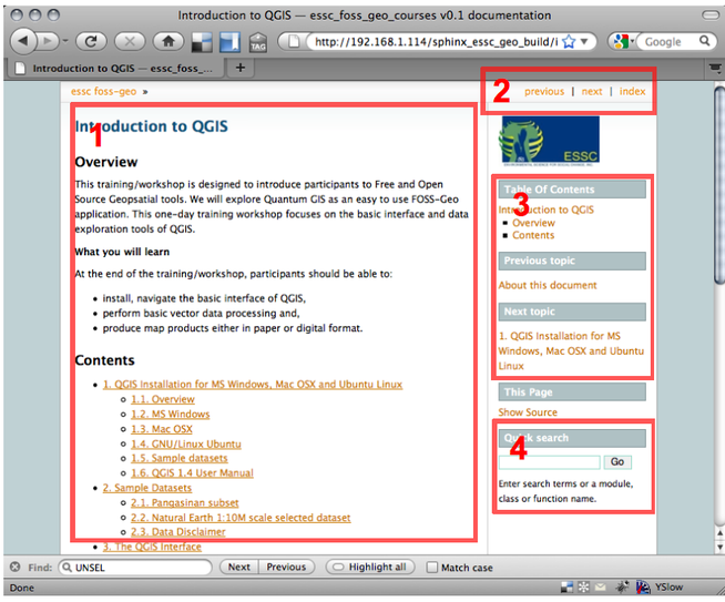
- 1 - This section gives you an overview of exercises. You can proceed to any topic by selecting any of the links in the table of contents.
- 2 and 3 - The sidebar navigation allows you to go to the previous or next topic.
- 4 - You can quickly search any word or term. Search results will direct you to the appropriate section.
Conventions used
Menu and toolbar commands are shown as italic letters and (if available) preceded by an icon image, for example, File or
 Composer Manager.
A series of commands are written with ‣. For example: File ‣
 New Project.
Keystroke combinations are shown as Ctrl+B, which means press and hold the Ctrl key and then press the B key.
Code or variables are indicated by a fixed-width font, for example:
some commands or variables here
Note
Text within this box indicates a tip, suggestion, warning or caution.
Corrections and feedback
For corrections and feedback, contact Maning Sambale emmanuelsambale@essc.org.ph
License of this document
Copyright (c) 2013 Environmental Science for Social Change and Fauna and Flora Philippines.
Permission is granted to copy, distribute and/or modify this document under the terms of the GNU Free Documentation License, Version 1.3 or any later version published by the Free Software Foundation; with no Invariant Sections, no Front-Cover Texts, and no Back-Cover Texts.
A copy of the license is included in the section entitled Document License.